
High Uintas - Middle Basin

Several weeks back, I was eying an opportunity to get my wife out further into the backcountry for one last backpacking trip before school started for our kids. We circled the 13th - 15th for a few reasons: 1) my mother-in-law was available to take the kids, 2) the Perseids would be active, and 3) it was mid-week for some solitude.
You can read through the details here or skip to my first attempt at a video report at the bottom...
Thanks to some great advice from many of many at BackcountryPost forum, we took our journey up the Stillwater way and opted for Middle Basin. We were not disappointed.
Unfortunately, as is typical, we got off to a later start than we wanted. We didn't leave the trailhead until about 11:30 am on Tuesday and didn't arrive at the shores of Ryder Lake until about 4:30 pm or so. We were hoping to have a camp set up before any afternoon storms had a chance to settle in. Fortunately, while we did get rained on, it was just a little bit for a small stretch of the trail while the cloud cover kept things nice and cool for us.
On our way up, one family of day hikers followed us out of the trailhead but they pulled off into the meadows not more than a mile up trail. After that, I don't recall seeing anyone until about a mile after the fork to Amethyst. There we took our first rest and came across a father and son who was setting up a camp nearby after coming down from Kermsuh that morning. We took our next rest at the Kermsuh fork where we saw two others on their way back down from the same lake. Once we got further up the Ryder Lake trail, there was one last group of what appeared to be a father and two teenage children on their way down and then a rancher and his little son up tending some horses and livestock in the basin.
Once we did reach Ryder Lake, we started working our way over and around the shoreline to look for an optimal site to camp. We did see one tent set up several hundred feet above Ryder so we continued on until we reached the end of the lake and onto Lake BR-17 right next to Ryder. It was there that I believe we found a suitable campsite. Believing it to be a bit more off the more traveled paths in the area, we settled in.

Shortly after setting up camp, I tried my hand at a little bit of fishing with no luck. Across the lake, someone else spent a bit of time fishing, presumably the owner of the tent that was camped out over and above Ryder. The rest of the evening was spent getting a fire ready and making some trail pizzas for dinner and sitting up waiting for darkness to take over so we could see what leftovers there were of the Perseids. The peak night for them was supposed to have been the night before. The moon interfered for the first little while however, but it didn't take long for it to disappear over the horizon. By midnight, I could have probably counted a couple dozen shooting stars within an hour before drifting off to sleep.
Wednesday morning we tried to wake up extra early but that's hard to do after a good hike up the day before and a late night watching the sky. The lake was as still as could be which made for a great reflection photo op.


We had hoped to find a way up to the summit of Mt. Aggasiz. The talus and boulder fields immediately beneath and around the base Mt. Aggasiz from where we were looked a little bit too steep and risky from down low. I surveyed the ridge all the way around the basin and concluded that the saddle just west of Hayden Peak would be the simplest and safest way up for a view and perhaps give us a safer path along the ridge up to Aggasiz. So away we went.


On our way down we opted to take a detour out to McPheters Lake. There we saw what may have been the same person from the night before getting their reel ready for some afternoon fishing. That would be the only person we'd see in our wanderings around the upper basin for the whole day.


From McPheters, we worked our way down and around the little ledges leading down to Ryder. We made a brief visit to the waterfalls along the northeast shore of Ryder where we became, if only for a moment, tempted to move our camp to the site at the base of the falls. Then we thought better of it knowing that anyone else who may want to come over for a visit would have to walk right into the campsite. After the waterfall, we returned to camp.
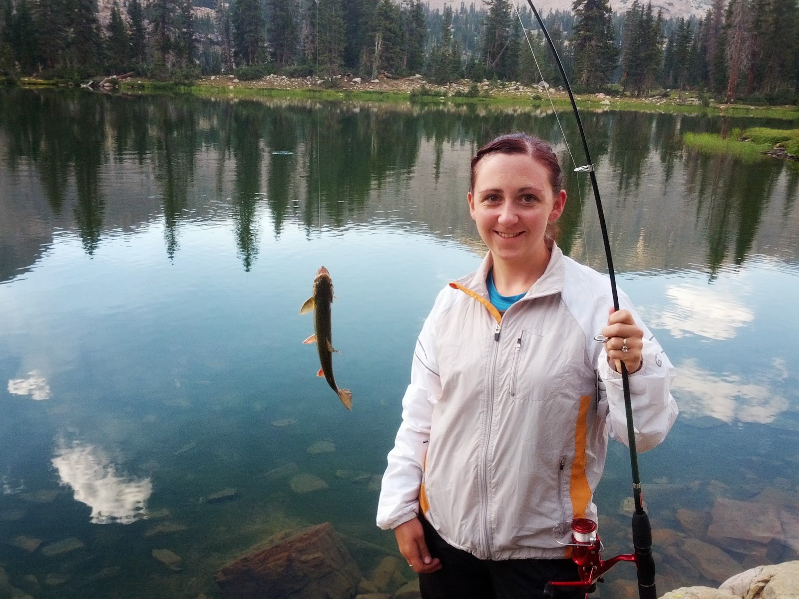
Jessica took a rest in the hammock while I attempted some fishing both at BR-17 and another lake with no name just below us to the southeast. After having no success with spinners, flies, and a bobber, I returned to BR-17 at the edge of our camp where I pulled the bobber off and put on a sinker to float some bait about a foot off the bottom of the lake. That proved to be the ticket as it didn't take long to start getting nibbles and then a hooked fish at last. Jessica joined in on the fun and reeled in another fish herself not long after. We were debating whether to let them go or not. We opted to keep them as an appetizer to our main dish. They were both Brooks, about 9 inches each.


On Thursday we had to bid adieu to Middle Basin and make our way back out. Less than a mile down from Ryder we crossed through the rancher's camp and herd of at least 500 sheep ranging all across the trail. As we moved further on down, it was incredible to see the amount of traffic on their way up toward Middle Basin that morning. Not only had a group of about 5 guys set up camp at one of the sites along the shore of Ryder the night before (and sometime after we had passed by earlier in the afternoon) but there was at least 5 other parties all equipped with overnight packs ranging from one person to four people in each party. In addition, we also passed by a family of horseback riders outfitted for a day of fishing as well as another family of day-hikers going up for some fishing. All of this trail traffic was encountered BEFORE the split off to Kermsuh. All were heading up the Ryder way. I state this to give a sense of how lucky we must have been to spend the nights when and where we did because it became obvious how busy and populated the area could become as the weekend approached. I can only imagine how many more people may have traveled up on Friday and Saturday.
I don't recall passing by anyone else between the Kermsuh fork and Amethyst. But, as expected, there was plenty of traffic, including some scouts, heading up the Amethyst way and possibly a couple more people toward Ryder or Kermsuh.
To officially conclude our trip, we made a stop at Summit Inn Pizza down in Kamas to gobble up some of their award-winning pizza. It's hard to judge it as worthy of an award myself since I think just about any fresh pizza would have been incredible to my palette after a long hike down from a few days up in the wilderness.


All in all, the trip turned out great. The weather treated us well and the mosquitos were surprisingly at a minimum.
I must state here that it's interesting how on an older National Geographic Trails Illustrated map I have of the High Uintas Wilderness, that of the three Stillwater Basins, only Amethyst is shaded in as a high traffic area. However, in checking the most recently revised TI map of the same area now sold, Ryder and McPheters and their surrounding area of Middle Basin is now shaded as a high traffic area. Only Kermsuh currently remains unshaded, but I imagine that as more people start to go there seeking more solitary seclusion from the other two basins, it won't be long before another revision has all three basins shaded off as high-traffic areas.
Word must definitely be getting out. It's certainly a picturesque area with plenty of places for fishing. I guess I'm now guilty for contributing to the traffic up there. I used to only scour maps and Google Earth looking for places to add to my bucket list that I thought was worthy of hiking and exploring myself. Now I find myself raking up destinations and trips to do from forums and other resources. I must say too that I also find it ironic how publications like Backpacker will often headline their covers with lines like "No Crowds! Secret Solitary Places in Your Own Backyard!", to which I always have to chuckle and sigh to myself…"Well, they were secret and solitary." No matter. I can certainly tolerate and even welcome others when I have to since it's only fair for others to be able enjoy and experience the same beautiful places, just so long as those who make up the crowds do their best to keep these wilderness areas clean and peaceful.


Leave a Comment