
Spring Break in Moab (April 2013)

- Day 1 -
Monday - April 1, 2013
Monday - April 1, 2013
We set out on our Moab adventure on Monday, April 1st. Our first stop was the Mill Canyon Dinosaur trail where there is a variety of dinosaur bones left in the earth exposed along the surface of some rock faces. They were mostly sauropod bones, but some stegosaurus and others were in the mix.
Below, the girls are posing in front of a collection of bones seen in the upper right of the picture.

A close up of the same bones below.

I'm not sure if this plant existed in the dinosaur ages, but in the manner of Dinosaur Kale, I gave it the name, 'Dinosaur Broccoli'.

Below is the remains of a petrified log caught in the rock.

After the Mill Canyon site it was already late in the day and time to head straight for a campground. Before the trip, our intent was to just reserve a spot in one of the local parks, but every single spot was booked every single night up through June. We were left with having to settle for anything we could find available in the first come, first serve campgrounds maintained by the BLM along the Colorado River. My wife and I had camped in one of these campgrounds before having children and found them to be decent and vacant sites were plentiful then. Of course, that was in the end of July a number of years ago when temperatures were at their hottest of the year. Little did we know just how in demand campsites are during the peak tourism seasons of spring and fall in Moab.
If you don't plan well enough ahead of time to reserve a site in a park or other reservable campsite, then you should pretty much plan to stay in a room for at least your first night and then do like so many others do: Drive up the canyon early in the morning and go on a scavenger hunt by stopping at every campground looking at the receipt tags posted at the front of each site for the current date. You then ask and confirm with the occupants if they'll really be packing out that day and if so, and if nobody else has laid claim on the site that morning, you fill out a registration slip and lay claim to it. Many will end up changing their plans and extending their stay beyond what they initially paid for, so don't expect a spot to be free just because the tag says the occupants' departure date matches the current date.
Fortunately for us, when we arrived at the last campground up the river for several more miles, Big Bend, the host saw us and given how dark it was getting, he took pity on us. He offered up one of his few available group sites for that night only and gave us the advice we needed to know to hunt down a spot early in the morning.
- Day 2 -
Tuesday - April 2, 2013
Tuesday - April 2, 2013
The following morning, armed with new advice, I set out for a site. After a few failed attempts with people who changed their plans as noted above and getting beat out by some others, I was lucky enough to come across a gem of a site further up in the campground where a young couple had packed up and was just finishing off a quick breakfast. The site turned out to be rather distant from any other sites so it was quite peaceful and pleasant not only for us, but for any that otherwise would have had to hear our screaming girls and the cries of a nine-month old. On a small scale, it turned out to be a nice example of: When one door closes, another opens. We felt very fortunate to acquire the spot we did and were glad the others we attempted to secure did not work out.


After our night of being nomads and securing a new home for our final two nights, we set off for Dead Horse State Park. Although my wife and I had paid a visit to Moab before, we only took time to see Arches. Neither of us had been to Dead Horse Point or the Island in the Sky district of Canyonlands yet, so we couldn't return to Moab and not take time to go in that direction. We had an in-car picnic at one of the picnic areas in the park while we waited for a rain shower to pass by. Soon after, the sun broke free for a bit and we set out on a little hike from the picnic area along the rim and out to the actual point where so many photographs have been taken. It's also become a popular backdrop used in many movies and TV shows. Anyone see Thelma & Lousie, City Slickers II or even the pilot for MacGyver?


It's a very popular spot for photographers as I have seen numerous pictures of it on post cards, art & photo galleries, books, and elsewhere. It wasn't on our "to see and do" list however until I had started combing over Panoramio photos on Google Earth in preparation for the trip that I discovered that False Kiva was right in an area we intended pass through. Needless to say, it became a must see.
So, we stopped at the visitor center just to get some additional info on how to locate the trail to it, (remember, it's not marked on any official maps) and to wait out some more rain. The ranger on duty was happy to oblige and even showed me some photos of some points to look out for and spelled out some guidelines to follow in order to help maintain and protect the site. We also picked up some Junior Ranger booklets for our two oldest girls to begin working on. As we left the visitor center, we were greeted to a spectacular view of a rainbow. We paused for a picture and then with the newly acquired trail info in mind, it was back into the car and further into the park we went.
So, we stopped at the visitor center just to get some additional info on how to locate the trail to it, (remember, it's not marked on any official maps) and to wait out some more rain. The ranger on duty was happy to oblige and even showed me some photos of some points to look out for and spelled out some guidelines to follow in order to help maintain and protect the site. We also picked up some Junior Ranger booklets for our two oldest girls to begin working on. As we left the visitor center, we were greeted to a spectacular view of a rainbow. We paused for a picture and then with the newly acquired trail info in mind, it was back into the car and further into the park we went.

Between the ranger's description of the trail and some others I had read online, I was still hesitant about taking the whole family on it. So my wife gave me permission to run out to the kiva while she stayed back and rested with the kids. If the trail was doable for the older kids and the younger ones in our packs, then we'd try to make time to return. In the mean time, the kids were all happy to chow down on some snacks and watch a movie while I took on the trail.
The trail seemed easy enough and was real gradual for about the first 2/3 of the way. At that point it lead out into the cliffs where the alcove that housed the kiva was located. The trail then become more boulder hopping with a bit of climbing, slick rock, and scrambling mixed in. There were enough rock cairns in place to keep me heading in the right direction and as long as I paused ever few moments to survey the side of the cliff, it became easy enough to find a suitable route up to the alcove.
While I had read that the very end, right under the alcove, the trail got narrower with a steep drop off along the edge, I found that wasn't really the case. The drop off along the narrow point was only 4-5 feet, maybe a bit more, with plenty of rocks and brush gradually sloped downward after that to catch oneself before really taking a fall. The narrow part was still a good 3-4 feet wide so one could still comfortably walk it without grasping for hand holds. Still, the latter third of the trail wasn't for the faint of heart. It's doable for anyone with a relatively good level of fitness but would probably be a bit more challenging for one who didn't consider themselves physically active. At last, I had made it up in the alcove, and wow, what a sight it was to behold. As it has for so many before me, it instantly became a place of reverence and awe. Behind the Kiva, there was a little trail register in a small ammo box with some additional literature about the spot printed out and a notebook for one to leave their comments in.
The words I left: Amazing, Sacred, Surreal!
By the time I had returned to the car, it was nearing sunset. By the time we got out of the park and closer to Moab, dark had settled in and instead of taking the time to set up dinner in the dark back at camp, we decided to stop at Denny's for a hearty supper.


After the taking a peek at Delicate Arch from its south side, we made our way back to the Windows area to catch up with a ranger-led hike to pass off one of the Junior Ranger program requirements. It turned out to be quite interesting. Not only did the ranger teach about Cryptobiotic soil, or "Crypto" as I call it, but also how the arches in the Windows area formed and how some varieties of plants have adapted to surviving in such desert conditions. Of particular interest was the Juniper tree. Its leaves are like tiny scales which have much less surface exposure which results in much less transpiration than plants with larger surfaces on their leaves. When drought conditions become extreme, it will even shut off water to a more aged part of the plant and essentially sacrifice a limb to conserve water for the survival of other newer growth. It was likened to Aaron Ralston who's now more famous thanks to the true story film, 127 Hours. Not long ago, he resorted to sacrificing his own arm off to free himself from a rock jam in a remote slot canyon in nearby Canyonlands National Park. Just below is a picture of the Windows and our ranger group in transition.

At the conclusion of the short hike, we lingered around a bit to rest and take in the other views of the Windows and surrounding area.


Right across a small loop from the Windows & Turret Arch trailheads is the trailhead to Double Arch, famously featured in an Indiana Jones film, if I remember right. Next to Double Arch is a sculpture of rocks called "Elephant Butte". Can you see the elephant?


After reviewing some photos from our 2006 visit, I had to throw this one in that was taken near Sandstone Arch.

At this spot, you can also take some shots of your kids in a cavity in the wall. They'll call it a cave.


For whatever reason, we didn't stop at Balanced Rock until we stopped back into the park the next morning as shown further below.


A little lizard in the tree next to the tent maintained the attention of our daughters while we finished packing up. Look closely in the middle and you may see its head poking out too.

Once we had finished eating and cleaning up camp, it was back into Arches. We stopped at the visitor center so the older girls could complete their Junior Ranger booklets and receive their Arches badges.

We then took the opportunity to take a couple of other roadside pictures with the morning sun. My wife thought the big rock below had the silhouette of the Sphinx on it. Look along the upper left of the rock.

After finishing up at Arches, it was back onto Canyonlands. We had to complete a hike so the girls could write about it in their Junior Ranger booklets. While I'm confident they could have made it out to False Kiva, the technicalities of the latter end of the trail would have made it rather time-consuming for our whole family. We opted for nearby Upheaval Dome. False Kiva for everyone else would have to wait for another day and another trip to Canyonlands.


After the hike and a brief stop at Green River overlook, it was getting later into the day and we still wanted to stop at a dinosaur track site on the way back home. I had hoped to also have time to stop at Mesa Arch and do the short hike to that, but everyone was ready to go, so it too would have to wait for another return trip.

On the way out of the park, we stopped back at the visitor center so the girls could complete their Canyonlands Junior Ranger booklets and obtain badges for that park.


Wildflowers were also plentiful in this area. My girls love them and I figured my gardener followers would too. Our two oldest also wanted to pose with some.
By the time I had returned to the car, it was nearing sunset. By the time we got out of the park and closer to Moab, dark had settled in and instead of taking the time to set up dinner in the dark back at camp, we decided to stop at Denny's for a hearty supper.
- Day 3 -
Wednesday - April 3, 2013
Wednesday - April 3, 2013
Wednesday morning proved to be significantly colder to wake up to than the previous morning. However, with a little help from some hot wassail, leftover Denny's pancakes warmed up in foil, and some yogurt, we were able to get back at it. We set off for Arches.
After a brief stop in the visitor center to pick up some Arches NP Junior Ranger booklets for our two oldest, it was up and into the park we went.
By far, the most popular attraction in Arches National Park is Delicate Arch. It's featured prominently on many Utah license plates. It alone seems to attract people from all over the world. My wife and I had done the hike right up to it during our past visit and knew that while it wasn't hard, it would consume most of the day if we took our kids on it.
Below are some images of Delicate Arch taken in 2006 from our previous visit to Arches.
Below are some images of Delicate Arch taken in 2006 from our previous visit to Arches.
 |
| Approaching Delicate Arch (2006) |
 |
| At the bowl of Delicate Arch (2006) |
 |
| Me standing under Delicate Arch (2006) |
 |
| Another Angle (2006) |
 |
| Petroglyphs along Delicate Arch Trail (2006) |
As seen in the pictures above, the arch is wondrous, but I think there are other spots in the park that are worthy of just as much, if not more, praise. For example, I find Double Arch to be just as fascinating.
So instead of the actual hike to Delicate Arch, we opted to hike to a viewpoint down on the south side of the arch. On the way to the overlook trailhead is the trailhead to hike right up to the arch. Wow! Not only was the lot completely full, but cars, campers, and even some buses were parked on both sides of the road for a good half mile thereafter. Each of the toilet lines also appeared to be several dozen people long. Indulging in the wiseness of our decision, we continued the short drive up to the overlook trailhead. We found it to be much less congested and much more kid friendly.
At the conclusion of the short hike, we lingered around a bit to rest and take in the other views of the Windows and surrounding area.
Right across a small loop from the Windows & Turret Arch trailheads is the trailhead to Double Arch, famously featured in an Indiana Jones film, if I remember right. Next to Double Arch is a sculpture of rocks called "Elephant Butte". Can you see the elephant?
To conclude the day we took the kids to play under Sandstone Arch. This might be the most popular spot for families in the park and it's obvious why. It's a great place for adults to escape the sun and get a nice rest in some shade while cooling feet off in the soft, cool sand while they can let their kids roam around a bit and play in the sand as if they were at a beach. It's like a micro slot canyon and the hike into it is quite short, only a quarter to a half mile from the trailhead. If there were only a trickling stream with a waterfall, it'd be a spectacular oasis. It'd also be much more congested with people I imagine.
After reviewing some photos from our 2006 visit, I had to throw this one in that was taken near Sandstone Arch.
 |
| Light piercing through canyon to Sandstone Arch (2006) |
From the mouth of the little canyon containing Sandstone Arch, you can look out and see where what used to be Wall Arch previously existed. Since it collapsed in 2008 it has now officially been named "Broken Arch".
At this spot, you can also take some shots of your kids in a cavity in the wall. They'll call it a cave.

After filling an hour with fun and clothes with sand, we drove through the rest of the park to see all that could be seen from the roadside. Prominent among the the many great spectacular roadside views was the Fiery Furnace, Skyline Arch, a panorama as seen from the Salt Valley overlook, and of course Balanced Rock.
For whatever reason, we didn't stop at Balanced Rock until we stopped back into the park the next morning as shown further below.
We returned to camp for our final night where we cooked up some tin foil dinners and s'mores.
- Day 4 -
Thursday - April 4, 2013
Thursday - April 4, 2013
We arose and broke camp. Not long after the sun came up, as I was getting some things packed into the car, I was greeted by another seeking out an available site. And so the torch to our beloved campsite was passed.
A little lizard in the tree next to the tent maintained the attention of our daughters while we finished packing up. Look closely in the middle and you may see its head poking out too.
Once we had finished eating and cleaning up camp, it was back into Arches. We stopped at the visitor center so the older girls could complete their Junior Ranger booklets and receive their Arches badges.
We then took the opportunity to take a couple of other roadside pictures with the morning sun. My wife thought the big rock below had the silhouette of the Sphinx on it. Look along the upper left of the rock.
 |
| Sphinx look alike? |
This rock sticking up from the side of this cliff along Park Avenue made me think of Nefertiti.
 |
| Nefertiti |
And of course, there was Balanced Rock.
After finishing up at Arches, it was back onto Canyonlands. We had to complete a hike so the girls could write about it in their Junior Ranger booklets. While I'm confident they could have made it out to False Kiva, the technicalities of the latter end of the trail would have made it rather time-consuming for our whole family. We opted for nearby Upheaval Dome. False Kiva for everyone else would have to wait for another day and another trip to Canyonlands.
The trail to Upheaval Dome was rather short but steep. Natural looking stairs made of strategically placed rocks made it all much easier, especially for the kids. Upheaval Dome is basically a wide massive hole in the ground. The cause of its formation is still debated today. One theory logically suggests, as most would probably guess, that it is the remnants of a meteor strike to the earth. Another popular theory suggests it that it wasn't a meteor or anything extra-terrestrial at all, but rather the result of some seismic activity pushing up on salt deposits from an ancient sea bed.
After the hike and a brief stop at Green River overlook, it was getting later into the day and we still wanted to stop at a dinosaur track site on the way back home. I had hoped to also have time to stop at Mesa Arch and do the short hike to that, but everyone was ready to go, so it too would have to wait for another return trip.
Somewhere in the distance below, the Green River converges with the Colorado.
On the way out of the park, we stopped back at the visitor center so the girls could complete their Canyonlands Junior Ranger booklets and obtain badges for that park.
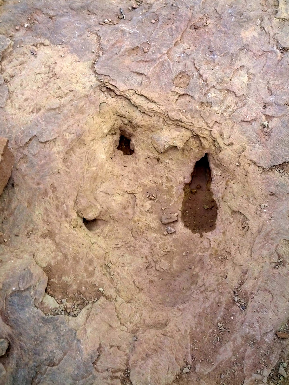
We ended our Moab adventure with a stop at the Copper Ridge Dinosaur Trackway site a few miles north of Moab before resuming our drive home. The site is unique in that it has at least three different dinosaur tracks preserved, including those of a sauropod (Camasaurus?) and an Allosaurus. They are also unique in that they are preserved in an ancient mud flow that is now hardened into a still fragile sandstone. Because the sandstone is so fragile, it is requested that people do not try to make plaster molds or do anything else with the tracks for that matter but observe, photograph, and enjoy. Because of the porous material the tracks are in, plaster can be absorbed and when removed, it can actually chip away and fragment some of the soft stone.
Wildflowers were also plentiful in this area. My girls love them and I figured my gardener followers would too. Our two oldest also wanted to pose with some.


Leave a Comment