
Spring Break 2016 - Southeast Utah

- Day 1 -
Monday - April 4, 2016
Monday - April 4, 2016
We woke up extra early to get an early start on the day after arriving in Torrey the night before to stay with Jessica's parents. In fact, her parents joined along for this day's activities. While we would end up camping this night, Jessica's parents would drive a lollipop loop in order to return home late in the evening.
Our first stop of the day was at Hite Overlook where the Colorado River feeds Lake Powell. As with many overlooks, spectacular views are enjoyed in all directions. It was a great place to stretch the legs and roam around a bit with the kids and the dogs.


Last time, I found a little mossy growth that I thought resembled a pumpkin. This time, some of the others found one that looked like a smiley face.

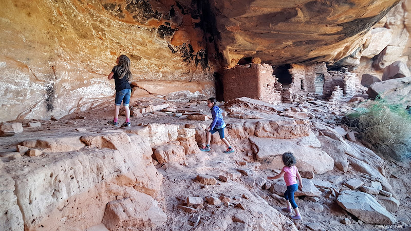
With Salvation Knoll now behind us, we drove a few minutes down the road to the Mule Canyon ruins site. This site features a partially restored kiva and some walls of a multi-room dwelling. The kids were impressed with it and they were happy they didn't have to hike very far to see the site. Only a 100 foot walk down a paved pathway is needed from the parking lot.


 Photo by Jessica Wickert
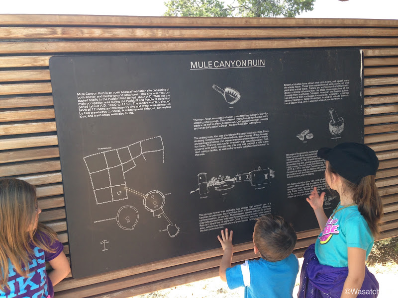 Photo by Jessica Wickert

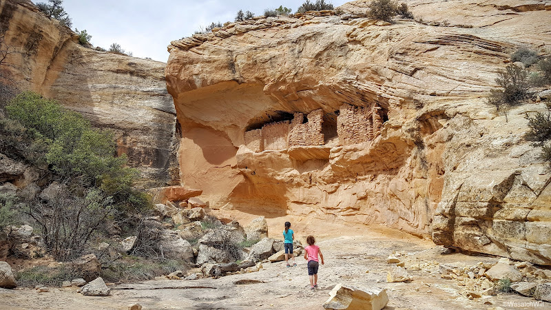
Before heading off to our next destination, we had a tailgate lunch at our cars. Then it was off down the road and up and over Comb Ridge and into Butler Wash where we hiked up to Target Ruin and Ballroom Cave. It was a toss up between hiking up to the House on Fire Ruin back at Mule Canyon and this one and I figured the kids would enjoy the uniqueness of Ballroom Cave much more than they would House on Fire, so to Ballroom we went.


On the recon trip with Lennox, we had made it up to the Ballroom first and then hit Target Ruin on the way back. On this hike with the rest of the family, we did the sites in reverse by doing Target Ruin first followed by Ballroom.

I led the kids and their grandpa up the opposite hill to see the concentric circle that gives the ruin its name.


On the way out from Target Ruin, some cactus that appears to have been eaten out of was noticed. We wondered what would take a bite out of such a plant and how they fared.

In typical fashion, the kids opted to slide down the steep and sandy trail back down to the main wash.

A little further up, we arrived at Ballroom Cave. As expected, the kids were impressed.


I did not take many pictures here since I took so many on the prior recon trip with Lennox. Intead, I just stood back and observed everyone else taking in the immensity of the cave behind the ruins.
By the time we returned back to the car, it was getting rather late in the afternoon. Since we were so close to Blanding, I had hoped to stop there and get in a visit to Edge of the Cedars State Park which featured a museum that housed a lot of Anasazi pottery and Basketmaker relics in addition to a restored kiva that can be entered via ladder. Since it was so late, however, I opted to bypass Blanding and lead the clan on down to Bluff where we'd make one last big stop for the day at the historic Bluff Fort.
In the fall of 1879, a party of Mormon pioneers embarked on a mission to establish a settlement in the southeastern corner of Utah. It was anticipated that the trek would only take 6 weeks upon leaving the town of Escalante, but they were soon delayed by a major obstacle: getting down to the Colorado River. They ended up having to make camp nearby for the remainder of fall while a crew worked to blast a road through a crevice that would became known as the "Hole in the Rock" while another team of scouts forged ahead to find a suitable route for the wagons to follow thereafter. Hence, the name of the trek became known as the "Hole in the Rock Expedition". It's also synonymous with other names such as the "San Juan Mission" and the "San Juan Expedition".
It wasn't until the end of January in 1880 that the road through Hole in the Rock was ready for the risky wagon descent. By virture of some incredible ingenuity, however, all the wagons successfully desceneded the Hole in the Rock and ferried across the Colorado River. They they made it through a few other major obstacles, including what proved to be perhaps the most challenging for the wagons, a rocky ascent up what became known as San Juan Hill. Due to the hardships encountered and exhaustion of all involved, both human and animal, they ultimately stopped at the shores of the San Juan River a day short of their intended target at Montezuma Creek further up river. They ended up building up a small town they called Bluff.
Today, the Bluff Fort is a joint operation between the city of Bluff, the Hole in the Rock Pioneer Foundation, and The Church of Jesus Christ of Latter Day Saints where many of the original pioneer cabins have been preserved and/or restored, a teepee, a Navajo hogan, along with a reconstruction of the community building that had originally burned down are all on display. Visitors can also enjoy a brief media presentation of the story of the journey to settle the area. A history scavenger hunt and other activities and props are available for the amusement of children.
A very nice gift shop is also on site which sells both pioneer themed products and indian art. It also sells ice cream and other yummy treats. Since the site has free admission, proceeds from the shop's sales are used for maintaining the site.
I had visited this site back in January when I came down to join some friends and acquaintances for the Bluff Balloon Festival and was so impressed by it that it's what got me determined to bring my family back down to visit the area and was thus put front and center on the table of options for this year's Spring Break.
Needless to say, we all thoroughly enjoyed the rest of the afternoon here and the kids got to pretend to be pioneers, cowboys, and cowgirls.


 Photo by Jessica Wickert
 Photo by Jessica Wickert

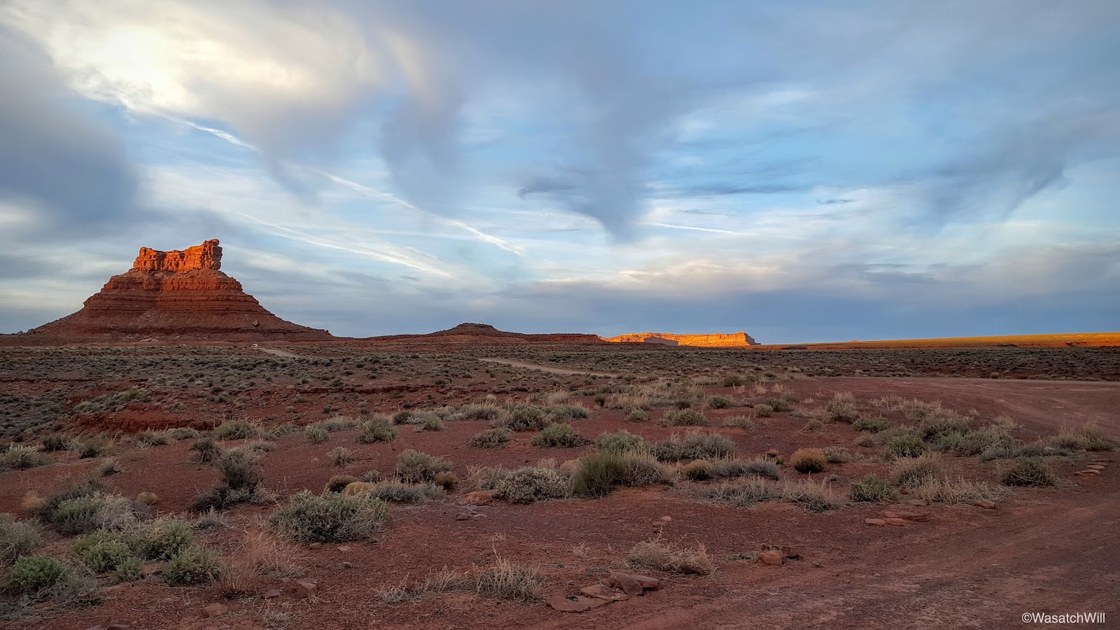
After our fun at the fort, it was time to make our way out to Valley of the Gods where we would set up camp for the night and say farewell to Jessica's parents as they would complete their lollipop loop drive back home.
I had picked out a handful of prime looking campsites on a drive through during my previous trip with Lennox and was actually astonished to find the first site I had in mind, which had some of the best views around including a view way out into Monument Valley, to be open and available.
We were grateful to get the site and enjoyed the sunset across the valley as we set up camp.


A dinner of grilled cheese sandwiches and soup was served before retiring into our tent under clearing skies for the night.
 Photo by Jessica Wickert
Our first stop of the day was at Hite Overlook where the Colorado River feeds Lake Powell. As with many overlooks, spectacular views are enjoyed in all directions. It was a great place to stretch the legs and roam around a bit with the kids and the dogs.


After piling back into our cars, we moved along down the road only to have me pull over moments later simply so I could run under the bridge over the Colorado to take a couple pics. There were no trolls to be found under the bridge, but there were some geese floating along down on the river.

We then headed for Salvation Knoll. Lennox and I had bagged this little peak on our recon trip a little over a week prior and it was fun to get the whole family up it this time. I had Jessica read the daunting book, The Undaunted, prior to this trip so she could be a bit more familiar with some of the landmarks we'd visit on this trip, including this spot. It's the perfect little peak for little legs to bag.

As I noted in my prior trip report, Salvation Knoll gets its name from an event back in 1879 where four scouts, part of the Hole in the Rock expedition of Mormon pioneers aiming to create a settlement down in the southeastern corner of the state, were out and about in the middle of December seeking out a safe passage around Grand Gulch and across Cedar Mesa to lay down a wagon road. Desperate to locate the Blue Mountains in order to orient themselves, their vision was continually obscured by Elk Ridge to the north. It wasn't until Christmas morning, having recently run out of food and believing their lives were soon to end, that they located a small cone shaped peak rising above the northern edge of the mesa whereby they were able to make a short scramble up to it and gain a whole new perspective of the mesa they were seeking to cross. It was there they were finally able to locate the Blue Mountains to the northeast and subsequently Comb Ridge across the east. Newly oriented with their surrounding, they now knew where they were to go and felt it proper to name the landmark Salvation Knoll, for to them, it had truly saved them.


Photo by Jessica Wickert
Last time, I found a little mossy growth that I thought resembled a pumpkin. This time, some of the others found one that looked like a smiley face.

With Salvation Knoll now behind us, we drove a few minutes down the road to the Mule Canyon ruins site. This site features a partially restored kiva and some walls of a multi-room dwelling. The kids were impressed with it and they were happy they didn't have to hike very far to see the site. Only a 100 foot walk down a paved pathway is needed from the parking lot.


Photo by Jessica Wickert
Before heading off to our next destination, we had a tailgate lunch at our cars. Then it was off down the road and up and over Comb Ridge and into Butler Wash where we hiked up to Target Ruin and Ballroom Cave. It was a toss up between hiking up to the House on Fire Ruin back at Mule Canyon and this one and I figured the kids would enjoy the uniqueness of Ballroom Cave much more than they would House on Fire, so to Ballroom we went.


Photo by Jessica Wickert
On the recon trip with Lennox, we had made it up to the Ballroom first and then hit Target Ruin on the way back. On this hike with the rest of the family, we did the sites in reverse by doing Target Ruin first followed by Ballroom.


I led the kids and their grandpa up the opposite hill to see the concentric circle that gives the ruin its name.

While we were up high, Jess and her mom stayed below with our youngest, Everett. While down there, they noticed some petroglyphs of some bird feet. My guess is that they represent turkey feet.

On the way out from Target Ruin, some cactus that appears to have been eaten out of was noticed. We wondered what would take a bite out of such a plant and how they fared.

In typical fashion, the kids opted to slide down the steep and sandy trail back down to the main wash.

A little further up, we arrived at Ballroom Cave. As expected, the kids were impressed.


I did not take many pictures here since I took so many on the prior recon trip with Lennox. Intead, I just stood back and observed everyone else taking in the immensity of the cave behind the ruins.
By the time we returned back to the car, it was getting rather late in the afternoon. Since we were so close to Blanding, I had hoped to stop there and get in a visit to Edge of the Cedars State Park which featured a museum that housed a lot of Anasazi pottery and Basketmaker relics in addition to a restored kiva that can be entered via ladder. Since it was so late, however, I opted to bypass Blanding and lead the clan on down to Bluff where we'd make one last big stop for the day at the historic Bluff Fort.
In the fall of 1879, a party of Mormon pioneers embarked on a mission to establish a settlement in the southeastern corner of Utah. It was anticipated that the trek would only take 6 weeks upon leaving the town of Escalante, but they were soon delayed by a major obstacle: getting down to the Colorado River. They ended up having to make camp nearby for the remainder of fall while a crew worked to blast a road through a crevice that would became known as the "Hole in the Rock" while another team of scouts forged ahead to find a suitable route for the wagons to follow thereafter. Hence, the name of the trek became known as the "Hole in the Rock Expedition". It's also synonymous with other names such as the "San Juan Mission" and the "San Juan Expedition".
It wasn't until the end of January in 1880 that the road through Hole in the Rock was ready for the risky wagon descent. By virture of some incredible ingenuity, however, all the wagons successfully desceneded the Hole in the Rock and ferried across the Colorado River. They they made it through a few other major obstacles, including what proved to be perhaps the most challenging for the wagons, a rocky ascent up what became known as San Juan Hill. Due to the hardships encountered and exhaustion of all involved, both human and animal, they ultimately stopped at the shores of the San Juan River a day short of their intended target at Montezuma Creek further up river. They ended up building up a small town they called Bluff.
Today, the Bluff Fort is a joint operation between the city of Bluff, the Hole in the Rock Pioneer Foundation, and The Church of Jesus Christ of Latter Day Saints where many of the original pioneer cabins have been preserved and/or restored, a teepee, a Navajo hogan, along with a reconstruction of the community building that had originally burned down are all on display. Visitors can also enjoy a brief media presentation of the story of the journey to settle the area. A history scavenger hunt and other activities and props are available for the amusement of children.
A very nice gift shop is also on site which sells both pioneer themed products and indian art. It also sells ice cream and other yummy treats. Since the site has free admission, proceeds from the shop's sales are used for maintaining the site.
I had visited this site back in January when I came down to join some friends and acquaintances for the Bluff Balloon Festival and was so impressed by it that it's what got me determined to bring my family back down to visit the area and was thus put front and center on the table of options for this year's Spring Break.
Needless to say, we all thoroughly enjoyed the rest of the afternoon here and the kids got to pretend to be pioneers, cowboys, and cowgirls.


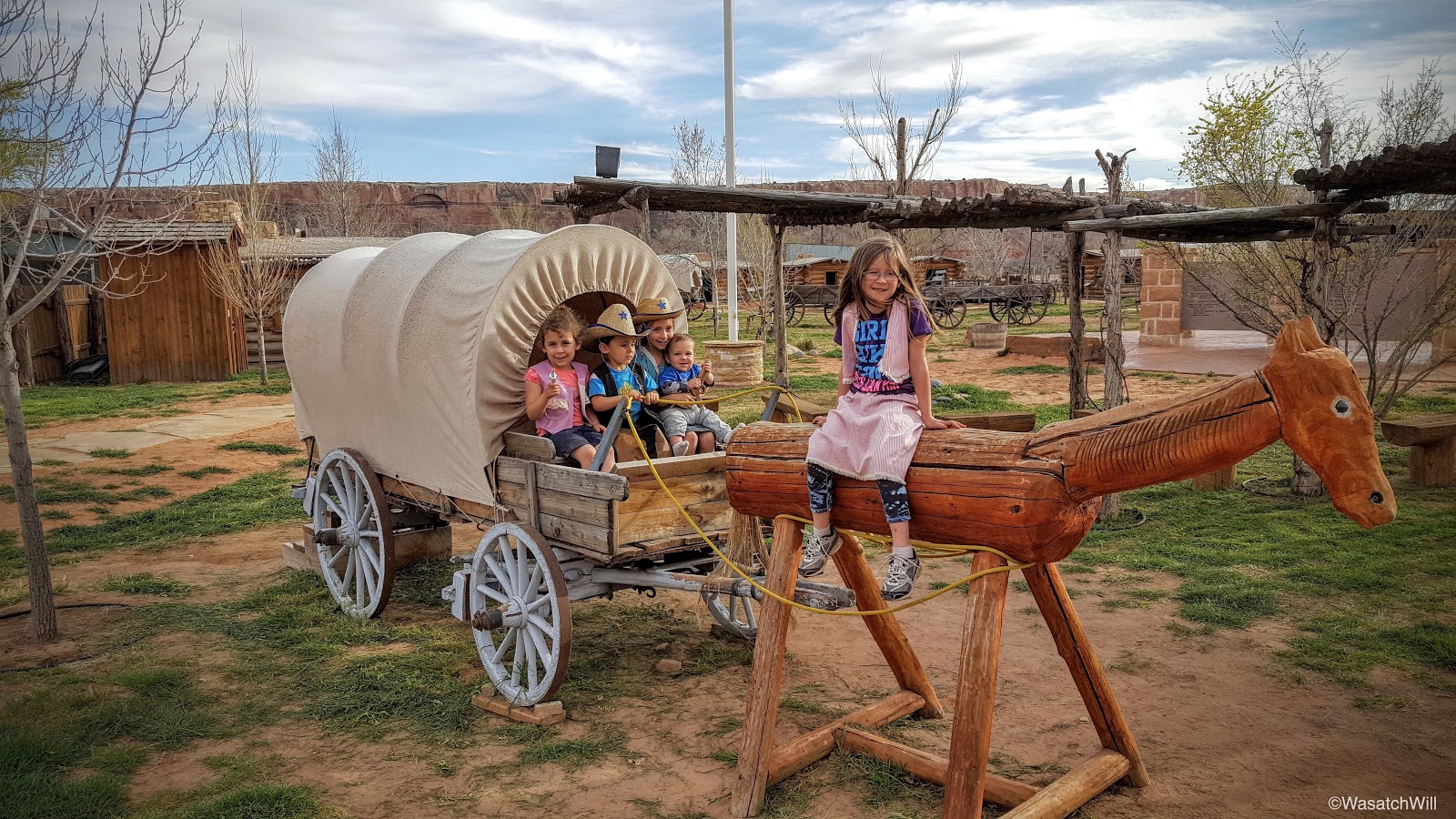


Photo by Jessica Wickert


Photo by Jessica Wickert
I had picked out a handful of prime looking campsites on a drive through during my previous trip with Lennox and was actually astonished to find the first site I had in mind, which had some of the best views around including a view way out into Monument Valley, to be open and available.
We were grateful to get the site and enjoyed the sunset across the valley as we set up camp.


- Day 2 -
Tuesday - April 5, 2016
Tuesday - April 5, 2016
We awoke to clear skies and a day full of sun ahead of us. With the sun now to the east of us as it rose, the buttes and mesa cliffs out to the west of us lit up for more spectacular views from our camp.


We had thought about buying a real camp stove for this trip, since all we've owned to this point are a few small backpacking stoves, but ended up borrowing one from Jessica's parents to ensure it was something that we'd want to get for future trips. We also borrowed a cast iron skillet. Not only did it work really well for the grilled cheese sandwiches the night before, but the setup enabled us to cook some pancakes to perfection. Being able to buy pancake batter already in a pitcher ready to receive just a bit of water and simply shaken up to mix can't be beat in terms of convenience and efficiency either.

It was tempting to keep our camp here, but there were another nice looking campsite I had in mind for the night to come back in Butler Wash that was close to a few other sites that we had on our agenda.
As we broke down camp, the kids enjoyed some free time playing in a sand patch nearby and constructing some little rock structures.


 Photo by Jessica Wickert

After we broke camp Jess suggested I take some shots of our minivan to give an idea of just how we made it work with all of our gear.
The backpacking packs stuffed in the back wouldn't have been there had it just been a family camping trip, but Jessica and I had plans to do a night or two of backpacking back in Capitol Reef later in the week. Also in the back was our food cooler, water cooler, and camp cookware box among some other little items stuff about.

All of our sleeping bags, crib for Everett, tent, air mattresses, camp chairs, and folding picnic table for the kids all fit in the cargo carrier atop the minivan.

Inside the passenger area of the van was a backpack for each kid containing some clothing, our food boxes, diaper bag, camp stove, camp kitchen table, etc. I don't think the van could have taken anything more, both in space and weight.

With all our gear loaded back into the car, we made our way along the rest of the road through Valley of the Gods, identifying what buttes we could along the way.
 De Gaulle and His Troops

 Looking back at Rudolph & Santa Claus and Castle Butte

Once we arrived at the junction with the highway, we headed south across the San Juan River to one of the most photographed roads in the world, also known now as "Forrest Gump Point" due to it being the scenic point where Tom Hanks, in the movie Forrest Gump, decides he's done running before a crowd of followers after running across the country a few times.

We could have continued on down into Monument Valley there on the horizon, but didn't want to spend the money it would cost only to spend a few minutes there to take a few photos and have a picnic. Instead, we made a U-turn back for Bluff and then drove on through to make our way out to Four Corners Monument where we'd spend money to have a picnic and take a few photos. But for the kids, this place was worth it for them to be able to say they got to be in four places (states) all at once.

It should go without explanation, but for those who may not be familiar with this monument, Four Corners is the only place in the USA where the borders of four states (Utah, Colorado, New Mexico, & Arizona) come to a single common point.


It turned out to be incredibly windy when we had arrived at Four Corners and it remained windy wherever we traveled for the rest of the day. We thought about stopping over at Hovenweep National Monument for a visit afterwards, but instead tried to make it up to Blanding to make another attempt at Edge of the Cedars. Unfortunately, we arrived there with only a half hour left before they closed, so we chose to save it for one last attempt the next day. At this time we still could have gone back out to Hovenweep with what daylight we had left, but given all the wind, we chose to just stick around Blanding for a bit to get some ice cream cones and play at the nice little park and playground they have in town there.
 Photos by Jessica Wickert
From Blanding, we made the quick drive back down to Bluff where we briefly stopped at the cemetery there to view the gravestones of many of the Hole in the Rock pioneers.
Afterwards, we drove on out to Butler Wash to set up camp for our second and final night of camping with the kids. This time, the site I had in mind was already occupied, so we settled for a nearby site that wasn't nearly as ideal, especially because it also serves as bit of a trailhead or a nearby petroglyph known as the "Big Crane".
Knowing that we were already losing daylight and that we'd be packing up and breaking camp right when the sun came out, we decided it'd be OK to camp there, given it had a fire ring established and all and then just hope we didn't make it awkward on ourselves or others should anyone show up to hike the "Big Crane" the next morning.


Along the way, the sun finally began to emerge and shed light across the upper reaches of Comb Ridge.

Flowers dotted the route up. Included among the featured flowers were some primrose.


There was also some scarlet hedgehog cactus blooms.


I continued to weave through the flowers along the side of the wash, scavenging the canyon wall until, there it was, the Big Crane.


Satisfied with the find, I headed back down to camp basking in the warmth of the new day's sun. I dodged a few wet potholes on the way back down.

And some dry.

The Comb was now fully aglow.

More flowers were there to greet me near camp. This time, some milkvetch.

The sun's light arrived back at camp about the time I did, so it was time to wake everyone up, get breakfast out, and get to breaking down camp.


Of course, the kids had to go out and do some more wandering and exploring while Jess and I cleaned up camp.
 Photo by Jessica Wickert
Once all packed up, we drove back down the wash toward the highway, making one quick stop to hike down to Wolfman Panel.

Yet another variety of flowers were to be found. This time it was some indian paintbrush.

Just a few moments after leaving the car, we were descending down into the wash.


The hike down to Wolfman Panel proved to be short and sweet as expected and we were soon gazing up at the variety of petroglyphs along the canyon wall preceding the actual Wolfman Panel.

I thought of Bigfoot or Sasquatch upon seeing this one.

Lennox made his own observations.

Then there was the actual Wolfman Panel.


I presume it gets its name, not because the man in the middle of it looks like a wolf at all, but because there appear to be two different wolf paw prints on either side of it.

There's also another crane in addition to a duck figure next to the man.


Some other interesting glyphs on the same wall included what appeared to be a plant, a shield, and a caterpillar face. There was also what appeared to be a bird upside down on skis, or so it seemed to me, though I know that's not actually what it was.


Another family moved on in and so we decided it was time to head back.


We pulled out at Hobbs Wash to read up on the plaque there. More Hole in the Rock pioneer history. This is actually near a spot inside a small canyon where the same scouts who found hope via Salvation Knoll just two days earlier, still without food and still uncertain about their survival, found shelter from a winter storm for a night.


Simply so the rest of the family could experience it, we drove on up the Moki Dugway.
 Photo by Jessica Wickert


Finally, we arrived in Blanding where we had ourselves a picnic lunch and got to tour the Edge of the Cedars State Park at last. There was quite a collection of pottery and other ancient relics on display there. Not quite as neat as seeing this kind of stuff in their original setting, but still very informational and educational.


One case had a collection of miniature pottery pieces. They were amazing. It was theorized that they could have been crafted as toys for children, or pieces children actually made themselves as they sought to acquire and model their parents' skills.

The museum also provided the kids with a picture scavenger hunt.

Especially interesting to me was a macaw feather apron found here in Utah. McCaws aren't native to the USA region, so it was evident that the ancient ones that had inhabited this area had trade routes and relations with those inhabiting Mexico and perhaps even further south.

At last, we found ourselves at the outside exhibit where some ruins had been restored, including a fully restored kiva that the kids really enjoyed.


Back inside we let the children have some fun with an indoor play area where they could use some blocks to build their own "ruins".


With the day getting later, we said goodbye to Blanding and started the drive back to Torrey. We'd make one final side trip out to check out the Castle Creek ruin site and the Clay Hills Pass, both points of interest along the Hole in the Rock Expedition route.
First up was the Castle Creek ruins.


On the way back, we pulled over to check out the view from Clay Hills Pass. This is another point where the Hole in the Rock pioneers had to drop their wagons down quite a steep slope to get them down onto Cedar Mesa.


It offered great views out across Cedar Mesa and Monument Valley out along the distant horizon.


Our final stop on the drive home was in North Wash near Hog Springs where we stopped to stretch the legs a bit and check out the Cleopatra pictograph.


Back in the car and on the approach into Hanksville, we were treated to a spectacular sunset.

It was a fitting sunset we'd drive off into as we concluded our spring break family camping trip.


Photo by Jessica Wickert
We had thought about buying a real camp stove for this trip, since all we've owned to this point are a few small backpacking stoves, but ended up borrowing one from Jessica's parents to ensure it was something that we'd want to get for future trips. We also borrowed a cast iron skillet. Not only did it work really well for the grilled cheese sandwiches the night before, but the setup enabled us to cook some pancakes to perfection. Being able to buy pancake batter already in a pitcher ready to receive just a bit of water and simply shaken up to mix can't be beat in terms of convenience and efficiency either.

It was tempting to keep our camp here, but there were another nice looking campsite I had in mind for the night to come back in Butler Wash that was close to a few other sites that we had on our agenda.
As we broke down camp, the kids enjoyed some free time playing in a sand patch nearby and constructing some little rock structures.


Photo by Jessica Wickert
After we broke camp Jess suggested I take some shots of our minivan to give an idea of just how we made it work with all of our gear.
The backpacking packs stuffed in the back wouldn't have been there had it just been a family camping trip, but Jessica and I had plans to do a night or two of backpacking back in Capitol Reef later in the week. Also in the back was our food cooler, water cooler, and camp cookware box among some other little items stuff about.

All of our sleeping bags, crib for Everett, tent, air mattresses, camp chairs, and folding picnic table for the kids all fit in the cargo carrier atop the minivan.

Inside the passenger area of the van was a backpack for each kid containing some clothing, our food boxes, diaper bag, camp stove, camp kitchen table, etc. I don't think the van could have taken anything more, both in space and weight.

With all our gear loaded back into the car, we made our way along the rest of the road through Valley of the Gods, identifying what buttes we could along the way.


Rudolph & Santa Claus (Photo by Jessica Wickert)


Lady in the Bathtub (left)
Once we arrived at the junction with the highway, we headed south across the San Juan River to one of the most photographed roads in the world, also known now as "Forrest Gump Point" due to it being the scenic point where Tom Hanks, in the movie Forrest Gump, decides he's done running before a crowd of followers after running across the country a few times.

We could have continued on down into Monument Valley there on the horizon, but didn't want to spend the money it would cost only to spend a few minutes there to take a few photos and have a picnic. Instead, we made a U-turn back for Bluff and then drove on through to make our way out to Four Corners Monument where we'd spend money to have a picnic and take a few photos. But for the kids, this place was worth it for them to be able to say they got to be in four places (states) all at once.

It should go without explanation, but for those who may not be familiar with this monument, Four Corners is the only place in the USA where the borders of four states (Utah, Colorado, New Mexico, & Arizona) come to a single common point.


Photo by Jessica Wickert
It turned out to be incredibly windy when we had arrived at Four Corners and it remained windy wherever we traveled for the rest of the day. We thought about stopping over at Hovenweep National Monument for a visit afterwards, but instead tried to make it up to Blanding to make another attempt at Edge of the Cedars. Unfortunately, we arrived there with only a half hour left before they closed, so we chose to save it for one last attempt the next day. At this time we still could have gone back out to Hovenweep with what daylight we had left, but given all the wind, we chose to just stick around Blanding for a bit to get some ice cream cones and play at the nice little park and playground they have in town there.

From Blanding, we made the quick drive back down to Bluff where we briefly stopped at the cemetery there to view the gravestones of many of the Hole in the Rock pioneers.
Afterwards, we drove on out to Butler Wash to set up camp for our second and final night of camping with the kids. This time, the site I had in mind was already occupied, so we settled for a nearby site that wasn't nearly as ideal, especially because it also serves as bit of a trailhead or a nearby petroglyph known as the "Big Crane".
Knowing that we were already losing daylight and that we'd be packing up and breaking camp right when the sun came out, we decided it'd be OK to camp there, given it had a fire ring established and all and then just hope we didn't make it awkward on ourselves or others should anyone show up to hike the "Big Crane" the next morning.

It remained windy as we set up camp, but soon after all the stars came out, the wind settled down and we had a very peaceful night under a clear sky full of stars once again.
- Day 3 -
Wednesday - April 6, 2016
Wednesday - April 6, 2016
While the rest of the family remained in their bags in the tent to sleep in and wait for the sun to emerge and warm the area up, I decided it would be more effective to get warmer by get up and going for a little jaunt up to see the Big Crane petroglyph for myself.


Along the way, the sun finally began to emerge and shed light across the upper reaches of Comb Ridge.

Flowers dotted the route up. Included among the featured flowers were some primrose.


There was also some scarlet hedgehog cactus blooms.


I continued to weave through the flowers along the side of the wash, scavenging the canyon wall until, there it was, the Big Crane.


Satisfied with the find, I headed back down to camp basking in the warmth of the new day's sun. I dodged a few wet potholes on the way back down.

And some dry.

The Comb was now fully aglow.

More flowers were there to greet me near camp. This time, some milkvetch.

The sun's light arrived back at camp about the time I did, so it was time to wake everyone up, get breakfast out, and get to breaking down camp.


Photo by Jessica Wickert

Of course, the kids had to go out and do some more wandering and exploring while Jess and I cleaned up camp.

Once all packed up, we drove back down the wash toward the highway, making one quick stop to hike down to Wolfman Panel.

Yet another variety of flowers were to be found. This time it was some indian paintbrush.

Just a few moments after leaving the car, we were descending down into the wash.


The hike down to Wolfman Panel proved to be short and sweet as expected and we were soon gazing up at the variety of petroglyphs along the canyon wall preceding the actual Wolfman Panel.

I thought of Bigfoot or Sasquatch upon seeing this one.

Lennox made his own observations.

Then there was the actual Wolfman Panel.


I presume it gets its name, not because the man in the middle of it looks like a wolf at all, but because there appear to be two different wolf paw prints on either side of it.

There's also another crane in addition to a duck figure next to the man.


Some other interesting glyphs on the same wall included what appeared to be a plant, a shield, and a caterpillar face. There was also what appeared to be a bird upside down on skis, or so it seemed to me, though I know that's not actually what it was.


Another family moved on in and so we decided it was time to head back.


We pulled out at Hobbs Wash to read up on the plaque there. More Hole in the Rock pioneer history. This is actually near a spot inside a small canyon where the same scouts who found hope via Salvation Knoll just two days earlier, still without food and still uncertain about their survival, found shelter from a winter storm for a night.


Simply so the rest of the family could experience it, we drove on up the Moki Dugway.


After taking in the views from the top of the dugway, we headed back for Blanding to see Edge of the Cedars. Along the way we pulled out into Butler Wash one more time for a quick visit to some dinosaur tracks there.


Photos by Jessica Wickert
Finally, we arrived in Blanding where we had ourselves a picnic lunch and got to tour the Edge of the Cedars State Park at last. There was quite a collection of pottery and other ancient relics on display there. Not quite as neat as seeing this kind of stuff in their original setting, but still very informational and educational.


One case had a collection of miniature pottery pieces. They were amazing. It was theorized that they could have been crafted as toys for children, or pieces children actually made themselves as they sought to acquire and model their parents' skills.

The museum also provided the kids with a picture scavenger hunt.

Especially interesting to me was a macaw feather apron found here in Utah. McCaws aren't native to the USA region, so it was evident that the ancient ones that had inhabited this area had trade routes and relations with those inhabiting Mexico and perhaps even further south.

At last, we found ourselves at the outside exhibit where some ruins had been restored, including a fully restored kiva that the kids really enjoyed.


Photo by Jessica Wickert


Beyond that was an interesting sculpture that demonstrated the art of shadows and the movement of the sun.


Back inside we let the children have some fun with an indoor play area where they could use some blocks to build their own "ruins".


With the day getting later, we said goodbye to Blanding and started the drive back to Torrey. We'd make one final side trip out to check out the Castle Creek ruin site and the Clay Hills Pass, both points of interest along the Hole in the Rock Expedition route.
First up was the Castle Creek ruins.


On the way back, we pulled over to check out the view from Clay Hills Pass. This is another point where the Hole in the Rock pioneers had to drop their wagons down quite a steep slope to get them down onto Cedar Mesa.


It offered great views out across Cedar Mesa and Monument Valley out along the distant horizon.


Our final stop on the drive home was in North Wash near Hog Springs where we stopped to stretch the legs a bit and check out the Cleopatra pictograph.


Back in the car and on the approach into Hanksville, we were treated to a spectacular sunset.


Looks like the trip was a success! You're car was packed to the brim! It's cute how you always line up the kids in their chairs or sleeping bags. From looking at your photos, I need to make another trip back to see/camp at Valley of the Gods. Neat to see that we visited some of the same places. - Alicia @ www.girlonahike.com
ReplyDeleteSuccess indeed! There is so much to see and explore down there. I still have a few things on my list of to-do's down that way, but I've been able to check off a good number of them in the few visits I've made down there going back to January. Jess and I also took a road trip through there one summer about 10 years ago before we had any kids to go visit Natural Bridges, Mule Canyon, and Edge of the Cedars before circling back up and settling into Moab for a couple of nights to explore Arches NP for the first time.
DeleteReally great pics, Will.
ReplyDeleteEnvious of you finding Big Crane, especially as it seems you had no trouble finding it. My wife and I, we're from England, Have tried, unsuccessfully, three times to find it but don't have any exact directions. Any chance you can help out?
Kind regards,
John
Thanks! If you can DM me on one of my social media platforms, I might be able to share some info that will guide you in the right area. I don't want to make the info public because of issues with vandalism down there with other panels that have become well known. Its location was shared with me by an acquaintance with good faith and trust and likewise, its hard to know who can be trusted with info about spots like this and will likewise not divulge it to the public to maintain the effort to keep these special sites protected from ill-willed or ignorant folks.
Delete